How To Plan an EV Road Trip With Google Maps' Charging Feature
Your EV’s built-in Google Maps app is designed to keep you charged.

For electric vehicles with Google Maps installed, road trips have become a lot easier. The popular navigation app can now manage vehicle charging along your route, meaning you won’t have to stress over making it to a station before your battery runs out.
What can Google Maps do?
Multiple modern EVs — like models from Volvo, Polestar, GM, and possibly even Rivian — come preinstalled with a specialized version of Google Maps that can directly tap into the vehicle’s systems to keep track of your trip.
Maps works directly with compatible EVs to keep track of your vehicle’s battery levels, energy usage, and other metrics to make sure you don’t run out of battery halfway through your journey. With this, Maps can also predict what your battery will be upon arrival.
Specifically, the app will generate real-time estimates of your remaining battery on arrival, and if you’re predicted to run out of power before reaching your destination, the app will prompt you to pick a charging stop to add to your route. If you need to stop more than once, the app will automatically add the necessary charging stops across the route, and these stops will be calculated into your trip duration.
Recently added Google Maps features focusing on charging will also help you find the right station to juice your EV at. The update allows users to look at a more detailed AI-generated description of where chargers are located (i.e. Enter the underground parking lot and follow the signs toward the exit. Just before exiting, turn right.) Hopefully, those summaries are accurate — AI has a habit of hallucinating information, and the last thing you need is to wander aimlessly in a parking garage looking for a charger.
The summaries should be rolling out to all Google Maps users in the coming months.
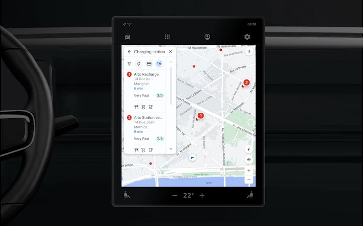
In addition to charger location summaries, Google Maps now shows nearby chargers on the in-car map and gives you real-time data on whether the charger is in use and charging speeds.
How do you access Google Maps’ EV charging feature?
Google Maps’ charging features are available for EVs like those made by Volvo which have Maps integrated into the car’s onboard computer.
Most of these features will engage automatically while driving, meaning you don’t have to do anything unless prompted to (like adding a charging station to your route when Google detects that you’ll need it).
However, searching for charging stations is pretty simple:
- Tap the “Search” button, and the search menu should open.
- Then, search for charging stations.
- From here, you’ll be presented with a series of filters to narrow down your search.
- You can search by charger type, payment network, or charging speed — including a filter for “very fast” speed that only shows 150 - 350kW chargers.
You can also manually add a charging station when creating a route:
- Search for a destination, and create a route
- Once the route has been generated, there should be a button labeled “Add charging stop”
- Tap this button, and select a charging station along the route.
Along with this, Maps’ voice recognition can be used to perform most of these functions without having to use a touchscreen while driving.
Currently, Google has not added an equivalent to the mobile version of Google Maps. However, the app can still be used to find electric charging stations. This can be done by typing in “electric charging station” into Maps — the same way you would search for a gas station — which will then show multiple stations in your area.
Tapping on these locations will provide additional information, including charging speeds, charger types, and availability of each.
However, because the mobile version of Google Maps can’t connect directly to an EV, it isn’t able to collect any information on battery levels or usage. As a result, it can’t accurately add charging stops to any trips.
This article was originally published on