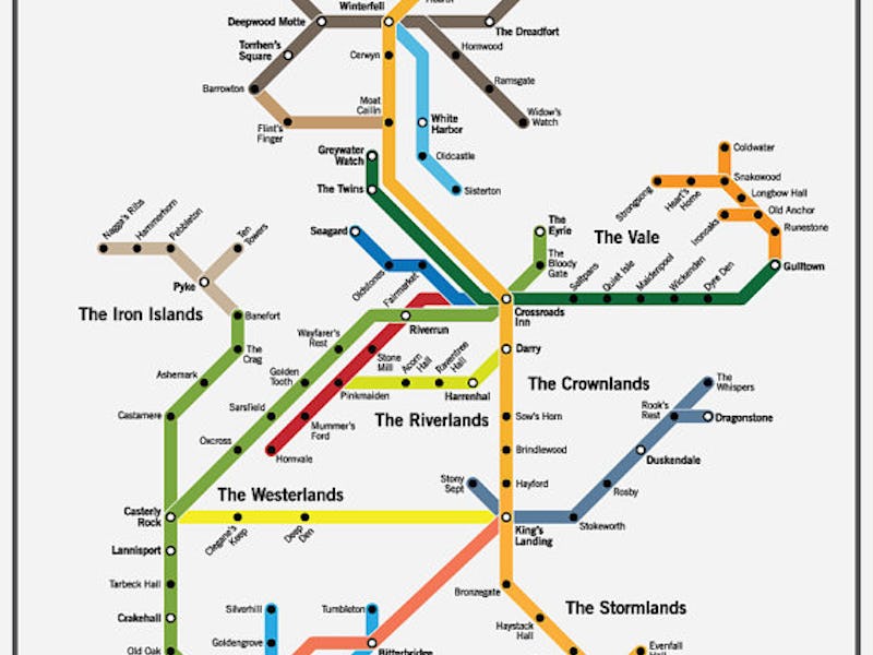
The families of Game of Thrones are — with one notable fire-breathing exception — limited to horse and carriage. But thanks to one designer, fans can now move through Westeros via the subway.
GoT-obsessed design company Fencing & Archery designed the map, which spans from the Wall in The North all the way south to Dorne. A high-resolution, zoom-able version of the poster, which sells for about $13, can be found in the Fencing & Archery Etsy shop.
But before you place your order — how accurate is the map really?
The subway map of Westeros is available for about $13 dollars on Etsy.
The answer is actually pretty accurate. The main features are all there, from the Stark family home at Winterfell to the increasingly foreboding perch known as King’s Landing.
The North and the Wall lines
And this design does the Wall — the only thing protecting Westeros from the White Walkers — justice, dramatically emphasizing its east to west route in the line at the very top of the page.
However, some lines appear to run underwater, like the tan route from mainland Westeros out west to the Iron Islands:
The Iron Islands
Not to take a fantasy map of a fantasy world too seriously, but ramming a tunnel under the ocean there would dramatically undermine the seafaring culture — and rock hard security — of the Ironborn.
And, inevitably, some of the routes are also changed to compose a map chock full of straight lines, instead of the ambling routes of reality. The yellow line from Casterly Rock to King’s Landing, for example, would actually have to make a sizable dip south if it’s really to make that stop at Clegane’s Keep. Maybe the lines could make use of the [hyperloop for high-speed connectionshttps://www.inverse.com/article/34067-hyperloop-one-announces-successful-full-scale-test.
A Google-ish Map of Westeros.
While it’s one of the more aesthetically satisfying works, Fencing & Archery’s subway map isn’t the only GoT map out there. In 2015, fans created the Google Map-style visualization of Westeros above.
And just this month, Google itself shared its Street View collection of real world GoT sets.
They all go to show how whether you’re in Westeros or the real world, maps are awesome — but always incomplete.
