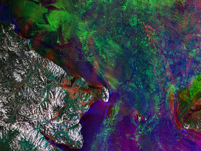
ESA Maps Show a Grim Future for the Melting Bering Strait
Most winters, it freezes over. This time, it didn't.

The European Space Agency’s Copernicus Sentinel-1 mission has some bad news for anyone who lives on Earth. On Thursday, ESA scientists shared a composite image and a video that shows how sea ice in the Bering Strait is melting much sooner in the winter than it normally does. Scientists agree that climate change is responsible for accelerating sea level rise, and this image demonstrates that subarctic ice melts aren’t immune to its effets.
To create this alarming map, ESA scientists stitched together three photos taken by the Copernicus Sentinel-1 satellite. The three images were each taken 12 days apart from the next — on December 11, 2017, December 23, 2017, and January 4, 2018. The satellite, which is part of the ESA’s Copernicus mission that monitors Earth, captures radar images, cutting through clouds to get right down to the surface of the Earth.
The resulting composite shows that ice in the Bering Strait between Alaska and Russia didn’t really form as it should have, and it receded quicker than usual. Normally, the Bering Strait typically freezes in the winter, but ESA scientists say warm currents from down south prevented that from happening as it normally does.
The Bering Strait, which normally freezes during the winter, remained unusually ice-free this winter.
The map is a false color image designed to help viewers tell how the sea ice changed between each photo. The first image was captured in blue, the second in red, and the third in green. All together, they give us a time-lapse portrait of the Bering Strait.
The warmer currents flowing northward, which are likewise unusual for this time of year, wreaked havoc on the normal freeze-thaw cycle in the Bering Strait. “As a result, areas that would have remained covered with reflective sea ice were open for much longer,” wrote ESA scientists in a statement. “The relatively dark surface of the sea was able to absorb a lot of energy from the Sun, which prevented sea ice forming in the autumn. Also, recent storms have helped to break up much of the sea ice that did manage to form.”
These various forces conspired to yield abnormally low levels of Bering Strait ice this winter.
While this particular incident included storms, which can’t necessarily be attributed to the longer-term patterns of climate change, the general trend for Earth’s sea ice is troubling. As ESA scientists explained, less sea ice means less surface that can reflect the warming rays of the sun. So if this pattern is a sign of what we can expect in years to come, then less Bering Strait sea ice could mean accelerating rates of sea surface temperature rise, which basically means everything gets worse a lot faster. Only time — and more data — will tell.
If you liked this article, check out this video where Bill Nye predicts the future of the environment.