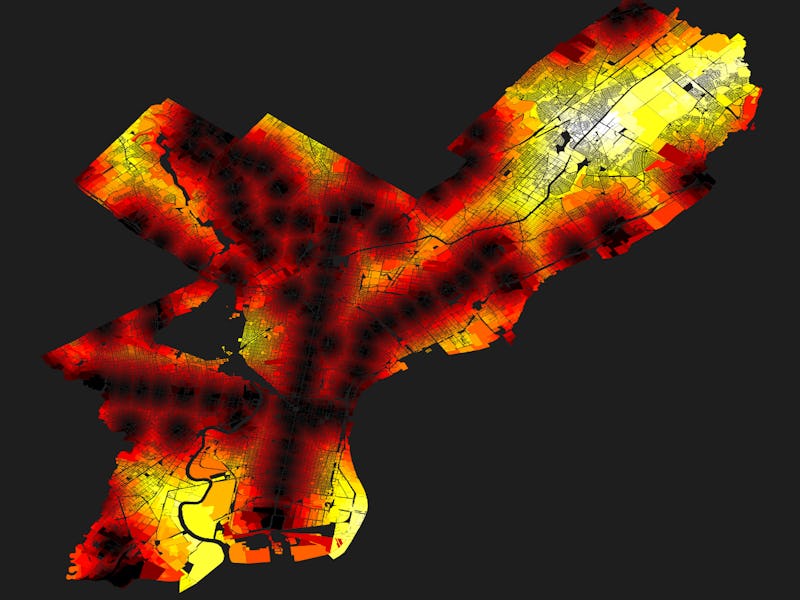
Anyone who’s lived in a city will know being close to a train station is crucial. But there are sometimes certain pockets of a city left without service, leaving residents to depend on bus or private transportation to get around. A new map by Max Galka, who teaches a course on data visualization at the University of Pennsylvania, shows how Philadelphia suffers from this issue. The map sheds some light on the disparities between different parts of the city, by showing which areas are served by the rail and subway services administered by the Southeastern Pennsylvania Transportation Authority, more commonly known as SEPTA.
“This map was from a class on geospatial analysis, just a fun example to learn the concepts — ranking each and every home by proximity to a SEPTA rail station,” Galka tells Inverse. The class was taught as part of the Master of Urban Spatial Analytics program, which focuses on city planning and public policy.
This transit desert problem is not unique to Philadelphia. London has a similar problem with areas south of the river. These areas also suffer from high levels of air pollution, as locals are pushed more to use gas-emitting cars over more sustainable public transit options. Leaving areas without transit options can have adverse effects, but sometimes it’s hard to spot where these areas lie.
Look at the map below. The black dots are the stations, and the brighter areas are further away from the train:
The Philadelphia map that shows distance to SEPTA stations.
Of course, the best solution to a problem like this is to build more stations and lines to serve other parts of the city. That’s what Chicago is doing, with plans to upgrade the Red Line at a cost of around $2.3 billion. Similarly, in the case of London, officials plan to extend the Bakerloo line into the areas least served by rail.
Unfortunately, SEPTA has some big challenges ahead before it can think of expanding into less-served areas. The city has only just started rolling out an electronic fare system, long a mainstay of other major cities, around three years later than scheduled. Much-needed rebuild and repair works, expected to cost around $5 billion, will stretch the system’s $1.4 billion operating budget to its extremes. The areas on the map may seem like they need better transit links, but a lack of funding means it could be a while until the network expands into other areas.
Update 3/3 6 a.m. Eastern: Added comments from Max Galka.
