Scientists May Use Gravity Map of Mars in Their Search for Life on the Red Planet
Map could provide clues as to where water -- and potentially life -- once existed on the red planet.

If you’ve ever wanted to get a good look at what the surface of Mars looks like, NASA (and even Google) can quickly offer a view. But if you’ve wanted to get a better look at what the inside of Mars looks like, you’ve been out of luck — until now.
NASA has just released a new, highly detailed “gravity map” of the red planet that glimpses the interior and where and how certain geological features have formed on the surface.
Gravity on the surface of a planet is, overall, smooth and the same no matter where you are. But there are minute anomalies scattered around the globe, where gravitational effects are slightly bigger or worse than the average during orbit. A gravity map basically shows off where those anomalies exist.
“Gravity maps allow us to see inside a planet, just as a doctor uses an X-ray to see inside a patient,” said MIT researcher Antonio Genova in a news release.
Understanding gravitational anomalies helps scientists better understand how a planet has formed, and can also provide insight as to how future explorers ought to go about studying a planet more precisely.
That’s why Genova and his colleagues have created a new gravity map of Mars. They published their findings in the July 1 issue of the journal Icarus.
There are three big takeaways from the new study. First, the new map points to a potential method for how some features formed across the divide of the smooth northern lowlands and the heavily cratered southern highlands. Second, the researchers confirmed that Mars has an outer core made of liquid molten rock. Third, the team observed how the Martian gravity has changed over the last 11 years — a single cycle of solar activity — and believe they have pinpointed the amount of carbon dioxide that freezes out of the atmosphere into the polar ice cap during winter.
The researchers developed the map using Doppler along with a slew of data gathered by three different NASA orbiters: the Mars Global Surveyor, Mars Odyssey, and the Mars Reconnaissance Orbiter. Each spacecraft can feel changes in the gravitational pull as it orbits the planet, due to the scattered lumpiness of the rock on the surface (for instance, gravitational pull is stronger over a mountain, but weaker over a canyon).
A map of Martian gravity looking down on the North Pole (center). White and red are areas of higher gravity; blue indicates areas of lower gravity
“With this new map, we’ve been able to see gravity anomalies as small as about 100 kilometers (about 62 miles) across, and we’ve determined the crustal thickness of Mars with a resolution of around 120 kilometers (almost 75 miles),” said Genova. “The better resolution of the new map helps interpret how the crust of the planet changed over Mars’ history in many regions.”
The most important part about the findings is that it could help to show where ancient rivers and waterways traveled underneath the surface of the planet, before they dried out or became buried over time. That’s crucial for scientists trying to investigate signs of past or present life on Mars.
A map of Martian gravity looking down at the South Pole (center). White and red are areas of higher gravity; blue indicates areas of lower gravity
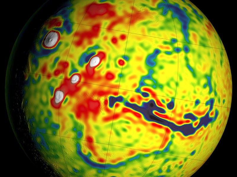
Of course, gravitational anomalies might be a consequence not from the way water has carved into the surface of Mars, but how the lithosphere — the outermost layer of the planet — has been formed, thanks to the Tharsis volcanic plateau, which has played a significant role in the evolution of the red planet.
The new gravity map has the biggest short-term impact on the ExoMars mission currently underway — the singular goal of which is to study Martian biology and determine whether life ever existed on the planet. Russian and ESA scientists might want to use the map when determining the best places to look for signs of life on Mars.
A Martian gravity map showing the Tharsis volcanoes and surrounding flexure. The white areas in the center are higher-gravity regions produced by the massive Tharsis volcanoes, and the surrounding blue areas are lower-gravity regions that may be cracks in the crust (lithosphere).