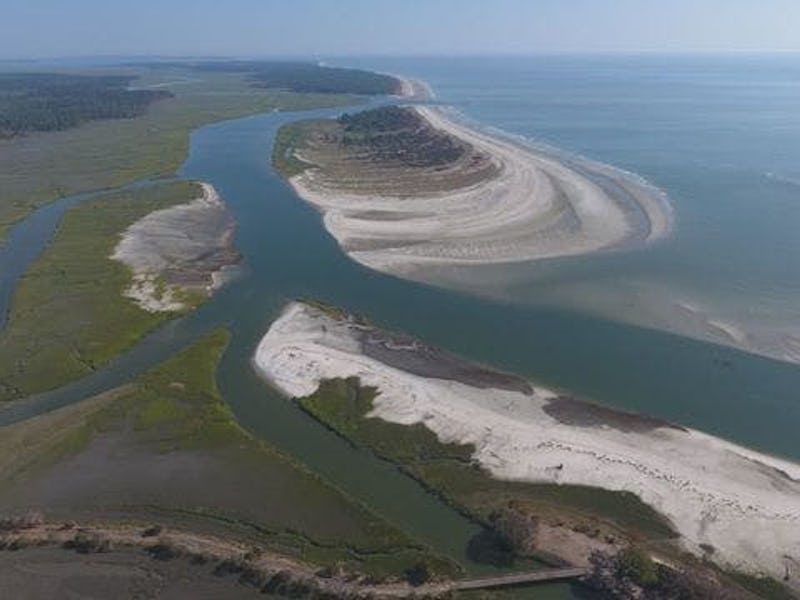
Little Blackbeard, New Island Created by Hurricane, Snubbed by Government
The Fish and Wildlife Service won't acknowledge its independence.

It’s been almost four months since Hurricane Irma ravaged the coastal southeast United States and Puerto Rico, but some of its stranger effects are only now coming to light. Off the sandy coast of Georgia, scientists armed with drone cameras recently discovered that Irma had sliced an existing island called Blackbeard Island in two, creating what is now being affectionately referred to as ‘Little Blackbeard’ by the Georgia Department of Natural Resources (DNR).
The United States government, however, doesn’t want to acknowledge Little Blackbeard’s independence. Blackbeard Island, which used to be a 5,600-acre strip of sand running parallel to Georgia’s coast, is federal land protected by the U.S. Fish and Wildlife Service (F&W), and the agency’s representatives are nonplussed about its recent division. Like an angsty teen, Little Blackbeard and its assertions of independence are being brushed off by its weary parents.
When asked whether Little Blackbeard would be recognized as a different island, Chuck Hayes, Ph.D., a supervisory wildlife biologist with the F&W’s Savannah Coastal Refuge Complex, told Inverse: “No, not at all.”
“It’s absolutely no surprise at all,” he continued. “Even without the hurricane, the staff was taking bets on when it was going to breach.”
Wes Robinson, the Director of Public Affairs at Georgia’s DNR, concurred with Hayes’ assessment. “It’s basically just sand,” he said in an interview with Inverse. “I’m not thinking this is going to be a long-term thing.”
Little Blackbeard was formed when Hurricane Irma shifted the channel of nearby Blackbeard Creek, which washed out the thin finger of land that connected the two sturdier sections of Blackbeard Island. In the drone photos taken by Marguerite Madden, Ph.D., head of the University of Georgia’s Center for Geospatial studies, the roughly 100-acre patch of sand that now forms Little Blackbeard looks very much like a separate island, but Robinson is doubtful about its permanence.
“The shore is always evolving a little,” he says. “Sand moves from some islands and moves to others.”
Before Hurricane Irma, Blackbeard Island's two larger halves were connected by the thin finger of land marked in red.
Such behavior is typical of barrier islands like Blackbeard Island (and now Little Blackbeard), which really are just long, thin deposits of sand and sediment that form offshore, parallel to the mainland. They form through the action of strong waves, wind, and currents, which push sand up into dunes that, if they build up high enough, poke out over the surface of the water. Barrier islands are often a shore’s first line of defense against huge storms, and it’s not unusual for them to sustain major changes to their size and shape during a hurricane.
“All those islands did what they’re supposed to do and take the brunt of the hurricane,” says Hayes. The only thing that the newfound autonomy of Little Blackbeard might change, he says, is the schedule that the island’s technicians have to adhere to; accessing Little Blackbeard to check on the loggerhead turtle nests protected there will now need to happen “at dead low tide.”
These disruptions likely won’t last long. A recent talk given by Madden at the Southern Forestry and Natural Resource Management GIS Conference in Athens, Georgia suggested that Little Blackbeard could give up its newfound independence and attach to Sapelo, the 16,500-acre barrier island that lies directly to its west. However, as Fred Hay, Sapelo Island manager for the Wildlife Resources Division of Georgia’s DNR said in a press statement, “Little Blackbeard also might just disappear.”
With today’s unpredictable weather patterns, it’s hard to say when that will happen.
Shelley Island unexpectedly formed off the coast of North Carolina in 2017.
It wouldn’t be the first time new islands have appeared and vanished on America’s east coast. In June 2017, a crescent-shaped island, almost one mile long, surfaced in the waters off North Carolina’s Outer Banks. Shelley Island’s sudden appearance was, like Little Blackbeard’s, not as astonishing to scientists as it was to locals and tourists, who were enamored with the unexpected sandbar. Then as now, scientists chalked its appearance up to the transient nature of barrier islands; in an interview with National Geographic, retired geology professor Stanley Riggs said “Nothing here becomes a fixture.” As it happens, Hurricane Irma was the storm that finally wiped out Shelley Island’s borders, connecting it to Cape Point on the mainland seashore.
“It’s just one of those things. When a hurricane comes along, we check to see what changed,” says Hayes. “It’s just a natural process of eroding and building.”