Here’s What a Massive Ancient Flood on Mars Left Behind
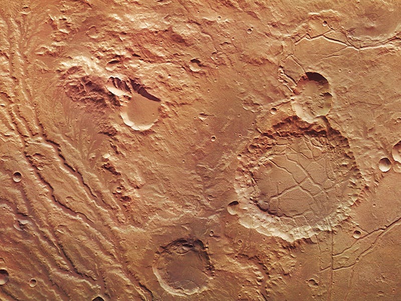
Martian water once gushed through this network of dendritic tributaries.

The European Space Agency’s Mars Express orbiter has captured a new photograph that highlights the remains of a massive system of streams and valleys on the red planet’s surface.
The image shows the region known as Arda Valles, a massive drainage system comprising the trails left by dozens of tributaries in the Martian highlands. The dendritic network is pictured, spreading like frost across the barren landscape, on the left-hand side of the artificially colored image below.
The Arda Valles region lies along the western rim of a 15-mile-wide impact basin, shown on the right side of the photo, into which vast floods of water from Mars’ southern highlands once flowed. The deep scars hatched across the basin floor are thought to be the marks left by the muddy sediments that originally filled the crater and later collapsed.
Lighter-toned regions to the left of the impact basin are evidence of clay mineral deposits, which are known to be formed in the presence of water. The ragged terrain to the right of the crater, divided into erratically shaped polygons, is thought to have formed as underground ice was lost and overlying sediments compacted on the surface over time.
The mound in the upper center of the image is punctuated by a 5.3-mile-wide impact crater at its foot. It’s thought the mound might be the remains of an even older impact basin, but it might also reflect the buildup of sediments deposited there by surrounding streams.
While scientists studying the origins of water on Mars will have to make do with these high-resolution photos for now, it’s possible they’ll get a much closer look sooner than we think, thanks to the ESA’s upcoming ExoMars mission set to launch in just a month.
3D view of Arda Valles.